Cruising Firth of Forth
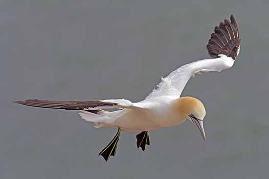
The Gannet
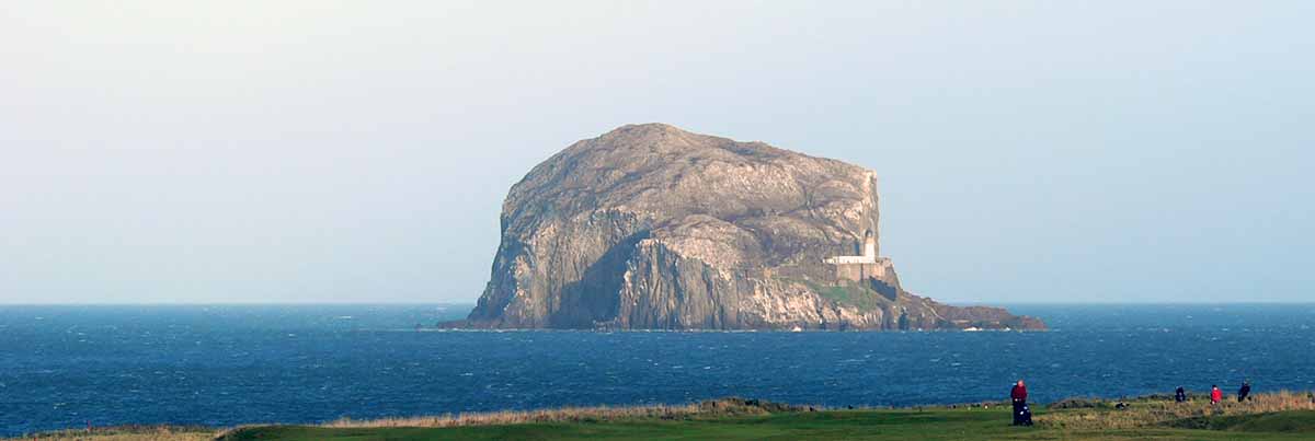
The Bass Rock is the closest sea bird sanctuary to the mainland and was the first to be studied by ornithologists during the 19th century, when they gave the Gannet the scientific name Sula Bassana, (Morusbassanus) incorporating the name of this rocky stack. This is the largest 'single rock' colony of northern gannets in the world (the largest colony at St Kilda is scattered over three sea stacks). The Bass Rock has been described by Sir David Attenborough as 'one of the 12 wildlife wonders of the world'.
The Puffin
An unmistakable bird with its black back and white underparts, and distinctive black head with large pale cheeks and a tall, flattened, brightly-coloured bill. Its comical appearance is heightened by its red and black eye-markings and bright orange legs. Used as a symbol for books and other items, this clown among seabirds is one of the world's favourite birds. With half of the UK population at only a few sites it is an Red List species.

PROPS & ROCKS
Coming out of North Berwick harbour people on another boat shouted to us “Watch your prop”. Well I did think it was a bit strange especially since I don’t have a “prop”. After we completed the circumnavigation of the Bass Rock and packing the boat away the helm of the other boat came over and explained that he did not say “prop” he actually said, “Watch the ROCKS”. Apparently, we sailed right over the top off them!

The Bass Rock One day cruise
.jpg)
A huge trachyte plug rising 313 feet, with three sides of sheer cliff, and a tunnel piercing the rock to a depth of 105 metres. The gentler slope to the south forms a lower promontory where the ruins of a castle stand dating back to at least 1405. The largest number of visitors to North Berwick fly in every year to set up home on the four offshore islands of Bass Rock, Craigleith, Lamb and Fidra. Around 150,000 sea birds nest on these islands with the largest colony on the Bass Rock, which has 120,000 occupied nest sites at peak season.
THE BASS ROCK is situated in the Firth of Forth,two miles east of North Berwick and one mile off the mainland. (Position on a Nautical Chart - 56` 4.6' N. 2` 38.3' W.)
.jpg)
Expensive launch fees Launching is off the beach and there is a day launch fee payable at the harbour office, for the GP14 this is £16.00 (2022).
.JPG)
.jpg)
Today I sailed around the Bass Rock and the Scottish weather lived up to its usual summer standard and it was grey dull wet day.
The sail went as planned and the whole trip took 3 hours. The weather may have been disappointing but the Bass Rock was not - it is a magnificent sight made even more magnificent by the sight of thousands of gannets. These are huge birds with a very bright yellow plumage on the neck and head. Amongst them were the little puffins with their colourful beaks often full of sand eels. Sailing without an engine meant that we could get quite close to the birds before they dived under the water.
Launch is down this ramp and on the beach. Make sure you leave your trolley above high water.
The journey was uneventful but interesting in that you needed to be aware of your position into the waves The boat coped with the surprisingly large swell coming up the Forth. Luckily there were not breaking but the old boat certainly wallowed and it was difficult to relax. On the windward side of the rock it was not a place to be hanging about as we were sideways on to the waves.
The sight of all the birds on the rock was certainly quite an experience and from a GP cruising point of view a worthwhile sail - but choose your launch time in that sailing 3 miles out into the North Sea has important safety considerations - we were fortunate.
18.06.2011
These details from the boatlaunch web site - a superb resource!
General information:
Long: -2.7184510231018066
Lat: 56.06029661372807
Nearest Place: North Berwick
Ramp Description: Very hard work on a making tide and an onshore wind. This is a very shallow shelving beach. Best at near high tide for launching. If launching at 1/2 tide bring waders. Coming back in is not so bad at lower tides. Have a long rope handy for towing boat and trailer to the foot of the slipway before hooking up otherwise you are in danger of bogging your vehicle down in the occasional soft sand patches.
Directions: Turn left immediately before the harbour, follow the road through the harbour flats car parking to the ramp. Just past the white flats the road narrows and turns down to the slipway. So be careful!
Ramp Type: Concrete leading to sand and flat rock mix.
Upper Area: Harbour
Lower Area: Sand
Suitability: Large trailer needs a car
Ramp Length: 1/4 tidal
Facilities: Toilets, parking. Cafe and chip shops nearby.
Charges: £8.50
Navigational Hazards: Watch the rocks to the North East of the harbour.
.JPG)
.JPG)
.jpg)
The Firth of Forth Bridges Afternoon cruise

Launched from Port Edgar. At the time Edinburgh Corporation owned the site. This place is directly under the 'old' road bridge. Since I have sailed from there a new road bridge has appeared. Good sailing area lots of places to visit (avoid Rosyth shipyard or you may get shot at or even run over by an aircraft carrier).
.png)

Passage Plan Notes
They are 'hopefuls' for the future and place for me to drop notes and suggestions.

Leave Port Edgar at last of the ebb. Deep shipping channel on the northside, expanse of mud flats on the southside.
Just after Blackness Castle at the eastern end of a shallow bay is the drying moorings of Royal Blackness Boat Club. (overnight?)

Leave early on a falling tide Bo'ess next town, large mud flats to the south will mean little water on a direct course.

At Kincardine bridge river narrows considerably to under half a mile. Will probably require aid of an engine to clear old swingbridge and the new bridge upstream from it. River Forth very muddy banks at this point. Dumnore next and possible stopping place. Tide should now be rising.

Long abandoned fishing vessels at the 'Inch' and wider river as more shallows.

Approaching Upper Tayorton bridge there is only 2.9 m clearance. Nowhere to land to lower mast to help do this. If continuing keep mast down.
Further up the river twist and turns (needs to be springs). After the Wallace Monument Stirling comes into view. New pontoon at the old jetty
High water at Stirling in TC Leith +1 hr 15 mins. Leave top of the tide to get back down. Can run at 6 knots (springs).
Mast can be raised again at Dunsmore. Lazy return option is to visit the Kelpies and entrance to Forth-Clyde canal. There is probably a 'double low water' here.
Take shortest route across shipping lane at Grangemouth and follow the north shore.
Forth Ports notice to mariners
In good conditions it is a lovely area to sail with iconic views and many historical features. Wild life is coming back with many sightings of whales and dolphins. Sailing under these sizes of bridges in a small boat is a experience you can probably only do on the Forth
Port Edgar slipway is wide and at times quite busy with commercial launching and sailing schools adding to its charm. The slipway does come to a sudden end at low tide and you may need some non-sail assistance to get out and back passed the moored boats and a jetty as they can shelter you from the wind.
Tides
Sailing here is tide Dependant. The spring range is up to 6 mtrs and most of the old harbours in the area will dry out or be silted up. There is an area just off Boness that dinghy sailors need to wary off as there is a long sandbank running parallel to the shore - so do use a chart. Use Leith as you tide guide and and don't trouble too much about secondary ports uunless you are going a along way upriver. Rates at times can be 4 knots under the railway bridge and further down the Forth two knots of tide in the area of Granton harbour.
Between Inchkeith and the bridges a west bound flood tide starts an hour earlier on the south shore than on the north one. There can be 'interesting' water turbulence in the Beamer Rock area (under the Queensferry Crossing Bridge). HW springs are in the afternoon head up river on springs and downriver on neaps.
Winds
Prevailing for the Forth are southwest to west, as result of tunneling effects of the land either side. The wind direction to be concerned about are the biting and often strong easterly winds. Wind over tide in this area can be uncomfortable and choppy.

Winds whipping the wave tops in a force 7 at Dunbar
Shipping
Big cruising ships park up east side of the bridges and will have an exclusion zone around them as the only way passengers get ashore is by taxi motor boat. Scenic cruise boats also ply there trade here and buzz around this area. The main shipping channel is on the north side with oil tankers and medium size containers ships making interesting traffic. Rosyth Naval Port is busy and will not welcome little boats nosing around. The working channel for the Forth is 71 so add that to 16 and you be OK. The shipping lanes are clearly marked. Assume sail (especially small boat sail) have 'no rights'.
Out of Bounds
Apart from the obvious Naval Base, especially stay clear the Crombie Pier area, next door. Inchmickery is an RSPB reserve. Inchkeith has unsafe buildings. Bass Rock and other islands should not be landed on, even outside the breeding season.
Call-ins
A good place to aim for is INCHCOLM. There is a landing place on the north side but avoid the parking at the pier as the day trip boat regularly calls in. There is ruin Abbey with an interesting history.
CRAMOND at the mouth of the River Almond is not far away and makes a nice place to stop for coffee. There is an Cramond Island just off shore can which provide good people watching when they get trapped on the island when the tide comes in.
Running from the shore is a concrete anti-submarine barrier called the 'Dragons Teeth'. I am assurred its possible to sail through them at high tide!

Limekilns has a couple of negleted harbours and a beach for giving the small boat sailor a break


The shores of the Forth have many interesting places to visit. Left is Crail and right is Culross.

Blackness Castle and slipway at sailing club

A few islands around bridges area. Inchgarvie looks like a battle ship!